

For rainfed agriculture in the Pampas and Chaco regions of Argentina, more than 35 million hectares with annual crops for grain or fiber, the weather in January is decisive. In the region, the demand for water to transpire from a total green cover is close to 180 mm, while the contribution from rainfall ranges from about 150 to 100 mm, on average, except in the extreme southwest where it only reaches 50 mm.
According to Jorge Mercau, who works from the INTA agency in San Luis, “the agricultural strategy seeks to reduce this water deficit, making the crops not have complete coverage in this month, trying to reduce drought, and/or avoiding locating the most critical stages for yield in it, trying to reduce the damage that drought can generate.” In addition, he added that “the availability of water in the soil is key to moderating the deficit and covering the potholes between rains.”
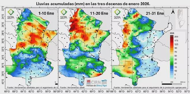
January 2026 wasn’t the exception to this agro-climatic framework, but the rains were uneven. In this sense, Lucas Gusmerotti, from the Institute of Climate and Water of INTA, said: “Based on the daily estimate of rainfall made by the SEPA platform, it can be seen that, in the first decade of the month, the rains were concentrated in the north of the agricultural area.”
La Pampa - Buenos Aires #
Santa Fé - Entre Ríos - Córdoba #
According to the specialists, “the events were very spaced out in some areas, but, in addition, the total for the month was very low in a strip that crosses the south of Entre Ríos and Santa Fe, the center of Córdoba and the east of San Luis.” Although this distribution already allows us to glimpse areas with possible water deficit, it is valuable to first integrate its effects in the recharge of the soils, from which crops extract water.
Pampean region - Buenos Aires #
Chaco - Argentine coast #
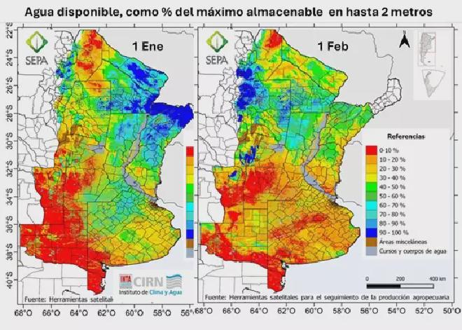
According to estimates, as of February 1, the warehouse would only have more than 50% in the Chaco region and the north of the coast, where there were good rains and the agricultural campaign has just begun. It is worth mentioning that, in this balance, the demand for crops is simulated from the satellite estimate of the green cover at each time and place, but how did these crops pass through?
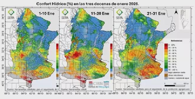
“For January, comfort remained high throughout the month in the north, due to the combination of the rains that occurred in the month and the storage of the previous ones,” Mercau said. In the west and south of the Pampas, on the other hand, low levels of comfort predominated. “In accordance with the rains, in the west they reversed towards the end of January, while in the south there were areas that, although they were in good condition in the middle of the month, ended up in drought,” the researcher specified.
Gusmerotti stressed that “the undulating Pampas started very well, as a result of the previous rains stored in the soil, but its state began to change in the second part of the month. As expected, the central strip that received little water is the one that would have suffered the most, with very intense outbreaks between Río Cuarto to the center-east of San Luis and in parts of southern Entre Ríos.”
“To measure the impact of these drought conditions, it is necessary to add at what time of their cycles the crops are in each region: In the Chaco region, summer crops are in implantation, they have a large part of the cycle ahead, especially their most critical stages that will only occur around March,” Mercau said. In this sense, he emphasized the importance of February starting with good recharge and crops that are doing very well, with a delay in the start of the campaign to the northwest.
“In the central strip, early corn was the most affected, to the west, where there was a fraction of the plantings on that date, there are lost crops. Further east, their yield can be good, depending on how much water they had available,” said the INTA San Luis researcher.
Corn & Soybeans #
South of Buenos Aires - Salado Depression #
Towards the south of Buenos Aires and the Salado Depression the outlook is also very complicated, with small areas that have arrived well, but to a large extent already have damage in part of the critical stages. The sunflower crop, which in general had a very good harvest from early sowing in the north and has suffered a little towards the west, depending on the initial availability of water, needs, like the other summer crops, more or less rapid rains in the south.
What’s next? #
It follows, then, that for the Pampas production, the rains that may occur in the short term are crucial, particularly during the first part of this month of February. “With a start with some rainfall, which is occasionally intense, two events associated with frontal systems are expected for the next few days that will leave rainfall around 30 mm in the provinces of Córdoba, San Luis, La Pampa and center-west of Buenos Aires, which may be overcome locally,” explained Natalia Gattinoni, meteorologist at the Institute of Climate and Water.
And she stated that “a pattern of rainfall that continues with a certain heterogeneity in the accumulated and zonally in the rest of the region, being scarce over the north of Argentina and the Littoral.”
Contact [Notaspampeanas](mailto: notaspampeanas@gmail.com)